Another easterly wind, another century ride – 112 miles including some backtracking. I wound up in Neligh, Nebraska, for the night.
The forecast for last night just called for showers, not thunderstorms. But at 2 am it poured, thundered and lightninged, and then the wind picked up and shook my little tent like it would go airborne. I put my wallet in the pocket of the shirt I wore to bed, so that if I had to make a run for the restroom in a tornado, i would at least have my ID and credit cards. But my little tent stayed put in the storm, and I stayed dry. The wind seemed to squash it down.
When I woke up, it was still raining. When it let up a little, I checked the radar. It looked like it would be clear for an hour before another heavy line of rain came through. So I decided to strike camp right away without cooking breakfast, so I could wait out the next line of rain under the roof of the camp office shelter. So I ate two bananas and a grapefruit for breakfast.
After waiting for the rain to clear, I finally hit the road at around 920 am. With an east wind blowing, but possible severe thunderstorms in the afternoon, my goal was to make the seventy miles to Norfolk, Nebraska before 2 pm when the severe risk started. I figured I could visit the bike shop there and have lunch and assess the prospects of pushing on up the Cowboy Trail before dark.
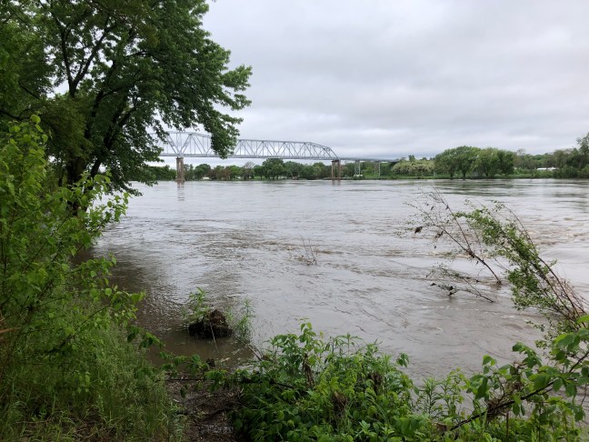 I soon reached the Missouri River, and took a mile detour to get a good picture of the bridge to Decatur, Nebraska. As it turned out, I could get coffee and a donut in Decatur (Google made it look like no shot at coffee until Norfolk itself). I sat down with my coffee and donut next to a slim, white haired woman with blank eyes, who was staring out at the cloudy sky. “We just can’t get a break from this weather,” she said. “There were tornadoes this morning south of here.” I asked if people were ok, but all she said was they tried their best people to safety, but it was so hard with the morning storms. She wished me luck on my ride.
Breaking news: Nebraska has hills. Real hills. So my downwind pace was limited a little by having to crawl up the hills every mile for the first fifteen miles or so. After that, the hills lengthened out, so that the uphill crawls were faster and the downwind downhill freewheeling went on for miles. I was soon making a good fifteen mph pace, on track to make Norfolk just before two.
The Nebraska landscape is somehow distinct from the Iowa landscape across the river. It feels more open, despite there being more trees, maybe because the hills give a commanding view. There seems to be more green, fallow fields, or just grass or hay growing. And more cattle in pasture, just as Iowa had more cattle in pasture than Illinois. At one point, a semi trailer laden with huge rolls of hay passed by me. A few miles later, I saw what looked like smoke, it it turned out to be dust from some kind of grinding machine that looked like a wood chipper turning out compost. The. I realized that the giant rolls of hay were feeding the grinder. And a few miles later I saw cattle in a feedlot devoid of grass, with a pile of that compost-like ground hay next to them. Do you think that counts as grass fed beef?

The rising and falling ride to Norfolk was otherwise uneventful, and just before 2 pm, I arrived at the Cleveland Bike Shop in Norfolk, which just happens to be the first bike shop I have seen since Cleveland. I asked Nick, the owner, to check my tires for wear, and he thought they had plenty of life in them. Nick pulled up the weather radar for me, and there were no thunderstorms headed for Norfolk. He also recommended the Rodeo Mexican restaurant as a good, cheap place to eat – and gave me directions, since there was no sign on the door. I went to Rodeo for a great burrito, and confirmed that there was no longer any threat of severe weather.
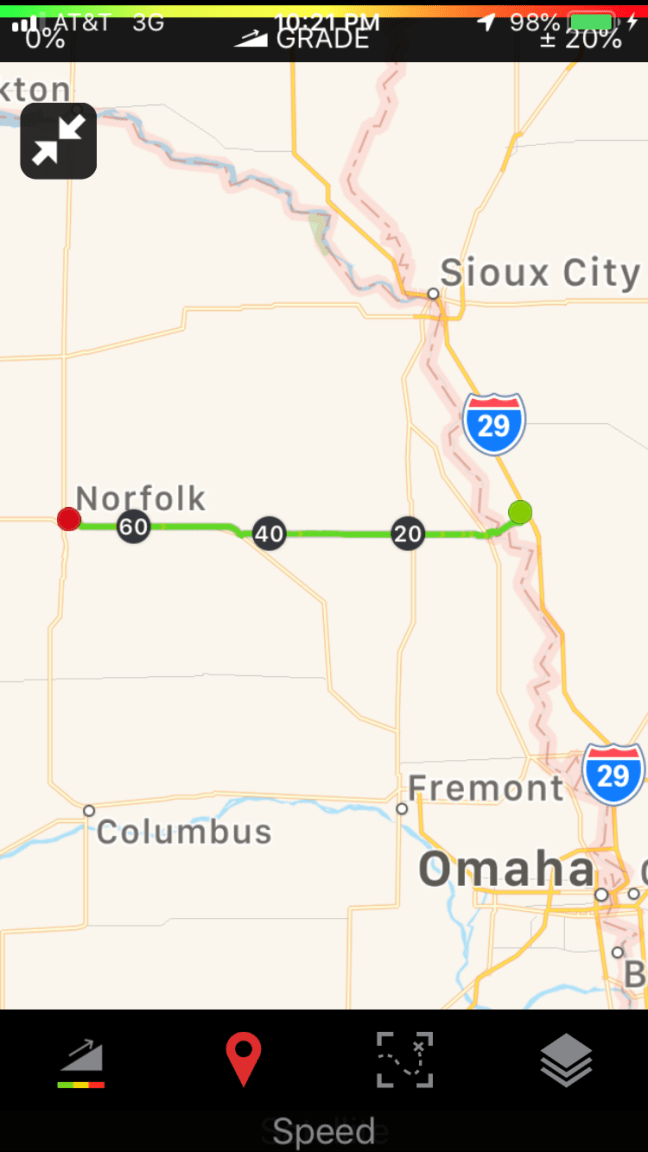
 With the east wind blowing, I resolved to start up the Cowboy Trail – a 187 mile rail trail that runs west from Norfolk to Valentine. I wanted to make a century of this precious downwind day, so with five hours daylight left, I set on Neligh, 35 miles up the trail and a place with camping available in the public park, as my destination.
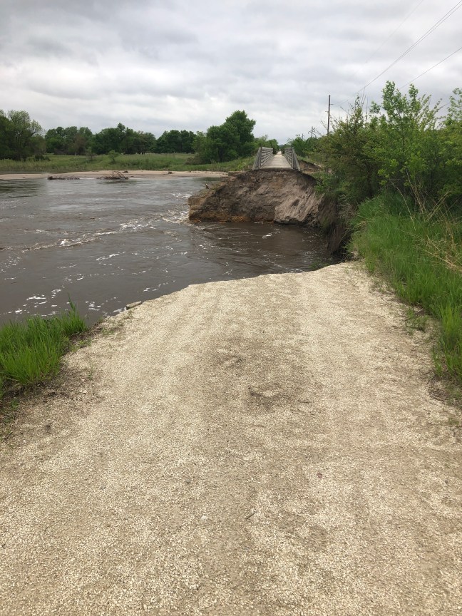
Portions of the Cowboy Trail are closed due to flooding damage, and I carefully took screen shots of the State map showing which portions were closed. The first ten miles were beautiful rolling alongside the Elkhorn River. Then I reached the first closed section at Battle Creek, and returned to Route 275 – a busy highway that at least has wide, smooth shoulders to ride on. It was smooth rolling downwind, so I did not return to the Cowboy Trail (which was softer gravel here) right away. But in Oakdale, it looked like the trail cut a straighter line to Neligh than the road, and I was ready for a break from the traffic. I stopped to check my screenshot of the state map, and confirmed that this section was open. Signs on the trail said otherwise, but the state website had to be right, right?
A mile down the trail there was tape across a trestle, and I ducked under it. The next trestle was more problematic: the approach was completely washed out by flood waters still roiling the bank.
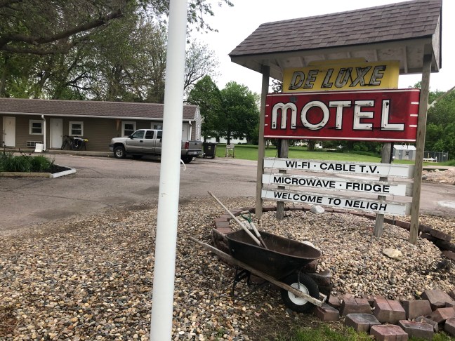 So I had to backtrack and cut across a dirt farm road to get back to 275. It started to rain again, and I decided to treat myself to a night indoors at the Neligh Deluxe Motel – an old fashioned travel motel with tiny rooms but more personality than the various “Inns and Suites” I had been staying at.